Tuesday, 31 August 2010

Day 2: La Clusaz to Bourg St Maurice

Distance: 57.51
Average speed: 10.20
Maximum speed: 33.35mph
Time in saddle: 5hr 28min

It's snow joke anymore. Today was very tough. Started with light drizzle and wet roads, straight into first hill which was the Col des Aravis (1486m), that was fine, this time the descent was extremely drops waiting for you if you got it wrong. With a slippery wet road this made for amn enjoyable thought.
Next climb up was the Col de Saisies, with the roads drying out and feeling ok, a decision was made to go for the top as quick as possible. Great idea Russ that one, as there was still the big hill to go and feeling tired.
Lunch stop was decided based upon which Restaurants were open, not many as it appears France takes Mondays off. Menu limited to quiche or quiche, so after a quick thought process, quiche it was. Trust me, you can eat too much quiche in your lifetime, and i have now maxed out on my quiche intake.
Final climb of the day and still nothing interesting to spot. OK, the odd bird of prey, but they were too far away for Dave to recognise.
Finally, with fear today was going to be a spot free day, I had to resort to tractors once more. This will please all my tractor fans out there. Added to my list from last year a Mantou looking rather sorry for itself, pic attached to keep all happy.
The last climb which was a combination of Col de Meraillets (1605m) and the Cormet de Roselend (1967) was a killer. Relentless was the only way to describe it. With about 9km to the top you get to the stunning lake, short stop for a photo and onwards and upwards.
Last 5km to the top had to be done in 1km thought mode, riding at a pittiful 5.5mph
The wind got up and the temperature plummeted, finally at the top to be greeted with....... NOTHING. Yes absolutely sod all, no cafe, no ice cream seller not even a drink station.
We had to wait for the rest of Team 43, by this time the SNOW, yes snow had decided to make an appearance. Shelter was provided by the bin store, all clothes I had went on.
On the way down some goats with bells were spotted, so again a pic must be taken. By this time, Dave realising the complete lack of clothex he had and sub zero temperatures meant for one thing, use Katies discarded clothes. A great sight, epecially when the jacket fails to do up, so on it went backwards.
At the bottom Bourg St Maurice greeted us. Into hotel, quick energy bar and the a sleep. Only i can do that!
Tomorrow apparently has a 30mile hill ready for us as the sadistic tour leader pointed out.

Monday, 30 August 2010

Sheep with bells

In all my excitement i forgot to add the 'sheep with bells' picture on my last post.
Please add comments to cheer me up.
Russ

Day 1. Thonon le Baines to La Clusaz -part 2

Distance: 58.61
Average speed: 9.83
Maximum speed: 30.01mph
Time in saddle: 5hr 57min

Setting off from a vantage point overlooking Lake Geneva and straight into the hills.
With 'Team 43' reunited for the first time, Dave, Katy and me set off.
With Dave leading the way and never driven or ridden abroad, there was extreme concern ad fear when he was see attempting the first roundabout in a very English clockwise motion. The French car drivers also on the roundabout seemed fine with this. Once I managed to get my breath back from laughing so much we carried on.
Spitting was thin on the ground, so it was decided to widen the scope. All there seemed to be was trees, chalets and mountains. Strange that!
Many cows about with bells on, very picturesque, but not good enough for a spot. We needed something more. Yes it was spotted. Sheep with bells on, see pic.
Off up the Col de Colombieré. The climb was relentless, not steep but hours iong. So, first hill done.
Descent somewhat quicker and faster.
50 miles in, no great 'motorised beds on wheels' to be seen, but then, like a mirage, there it was. Only I had seen it. Yes, a Ford Transit Ice Cream van converted to a camper. Was i a happy chappy.
My day was complete, off to the chalet for some rest a half a lager or two.
Sorry this post was a bit short, but hungover this Monday morning and not happy. Raining outside, mudguards in Kent.

Day 1. Thonon le Baines to La Clusaz

What to spot???????
Last year was easy, interesting subject matter like tractors and caravans already done, what else is there? In a foreign country with language skills limited to the ability to announce my name and my current age (not great when that is the age i attended my last French lesson). So there i was, 13 years old again.
Spotting was in short supply, my game plan was hatched a week before, when i saw an old Ford Sierra converted to a camper.
So, 'motorised beds on wheels it was'
Usual sfuff like VW campers not allowed, i'm talking ones that shouldn't be on the roads or up the Alps.

Day 0 - Travel Chaos

Saturday was the day we booked for Easyjet to take us from Gatwick to Geneva. Had we known what they had in store for us, it would have been quicker to drive.
Got to Gatwick at 9am, got to Geneva at 5pm. Not happy.
With a couple more hours to kill, a quick trip into Geneva centre for Dave and myself was on the cards.
Little did we know, this waa purely a wallet emptying session to finance the Swiss economy.
10 minute taxi ride and 40 Euros lighter was just the start.
Somewhere cheap to eat in Geneva was not possible, just finding a place to eat where a second mortgage was not required was near on impossible. This place was truly posh and we felt way out of our depth. Where's a descent chippy when you need one? Kebab house, no chance.
Pizza it was, bank account empty.
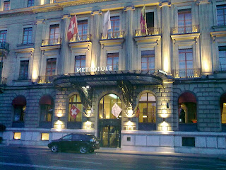
Picture of hotel we were not in. Off out into France to stay in a cheap B&B.
Ready for the start tomorrow.

Geneva to Nice in 7 days

It was decide that last years trip from Lands End to John O'Groats didn't have enough hills, so this year it was decided we should find a few more. So, it was decided that Geneva to Nice over the Alps in seven days should bring in a few more.
Last year there were three of us that made it to the end Dave, Katy and myself, Katy being our enlisted map reader, Dave our resident moaner and me my normal chirpy self!
So, first things first, we needed to get the band back together for part 2.
This seemed somewhat easier than first thought, so all signed up and ready to go.

Friday, 27 August 2010

The big cheque handover

End of last summer handing over the money!
No truth in the rumour I kept it for myself.
Thank you once again to everyone who sponsored me.

Wednesday, 24 June 2009

Job done - Lands End to John O'Groats


So I finished all in one piece and back to work now !

Many thanks to everyone who followed my blog and to those who have pledged some money to the Oliver Fisher Charity.
I will be contacting you all very soon and once I have the money collected will be presenting it to the charity.
I will then let you all know the exact amount we raised and thank you all once again.

In the meantime, the blogging will stop, as too will the tractor spotting!

All the best to you all and I appreciate your contribution.

Russell

Sunday, 21 June 2009

Saturday day 15, Bettyhill to John O'Groats

Distance: 64.79 miles
Average speed: 14.41mph
Max. Speed: 35.16mph
Time in saddle: 4hr 29min
Total distance: 1103 miles
Soreness rating of nether region: 0 out of 10 (sorted ! )

Final day and we immediately find the best bit of Bettyhill, that would be the road out! Not great place to stay.
Weather was gorgeous, no rain today, a first for us in Scotland. Along the coast road east aiming for John O'Groats, our final destination.
Past the Dounreay power station which is currently being decomissioned , the land will be ready for reuse in 2294, so I won't be buying land there.
Fifteen miles from John O'Groats and we make detour to Dunnet Head, which is the most northerly point on mainland Scotland. Just lighthouse at the point. Picture above. Once we ticked that off our list onto John O'Groats. Get there without trouble, hotel is all sectioned off an closed down some years ago. So, other than the car park and sign, not a lot else. It makes Lands End look like Las Vegas. Apparently their is start/finish line at the hotel, but we didn't see it.
Get the pictures taken to prove we did make it and off for glass of champagne to start the celebration.
Then on to Duncansby Head the most north easterly point past John O'Groats which nobody has heard of.
Just lighthouse there, but worth going to see, thd cliff face has Puffins an many other birds nesting there.
Back to John O'Groats and pack the bikes up.
Job done, I will post some thought and more pictures in the next couple of days.
Many thanks to everyone for their support and pledges. I will do an update on sposorship in the next few days also.
Currently at Inverness airport waiting for flight home.

Saturday, 20 June 2009

Dunnet Head

Just got to Dunnet Head. Most northerly point of mainlad Scotland
15 miles to John O'Groats !


www.rwheeler.co.uk

GPSed Track "Saturday, day 15 am"


View my new track "Saturday, day 15 am"

Powered by GPSed.com - Free Mobile GPS Tracking Service


Friday day 14, Evanton to Bettyhill

Distance: 80.92 miles
Average speed: 13.28mph
Max. Speed: 31.53mph
Time in saddle: 6hr 5min
Total distance: 1039 miles
Soreness rating of nether region: 0 out of 10 (sorted ! )

The penultimate day and guess what, it was raining. The aim was to get all the way to the top of Scotland as far as the Atlantic Ocean.
Never use the words 'at least we have a tail wind' until you know the direction you would be travelling in for most of the morning. A lesson learnt I think.
It seems that more and more people within our group are taking tractor spotting seriously, as you ca see in the picture above, after cycling round one corner only to find another member of the group proudly on top of a somewhat delapidated Massey Ferguson.
Into the headwind we go and onto a pub for lunch, absolutely in the middle of nowhere. Strangest pub you will ever go in, using customers as extra staff, but not even loca'' customers, just tourists!
With 40 miles left to Bettyhill, the direction of the wind becomes somewhat better and the pace is a little better. My sense of humour is rather lost after seeing sign which say 26 miles to go, when I had it fixed in my mind, we had about 10 to go.
Clocked up the 1000 mile of the trip, photos above and saw the very first sign for John O'Groats.
Onwards to Bettyhill, which is something out of the wild west. One shop and one hotel and one pub whuch is part of the hotel.
All you an say is that the view from our hotel window of the atlantic is stunning, other than that, the place should be removed from the face of the earth. Not great place and hope I never see it again!
The last picture is from our hotel window.
Last day on Saturday, looking forward to it now being ovef. Had enough of living out of bags for two weeks, each hotel room having it's own quirks. Tomorrow will be job done assuming nothing goes wrong.

Friday, 19 June 2009

Stop press - Bettyhill arrival

Made it to Bettyhill. North coast of Scotland. View from our hotel window.
Town is like something from the wild west. Not recomended!


www.rwheeler.co.uk

GPSed Track "Day 15pm"


View my new track "Day 15pm"

Powered by GPSed.com - Free Mobile GPS Tracking Service


GPSed Track "Friday am, day 14"


View my new track "Friday am, day 14" started in United Kingdom, Scotland, Inverness.

Powered by GPSed.com - Free Mobile GPS Tracking Service


Thursday Day 13. Fort William to Evanton

Distance: 84.6 miles
Average speed: 13.46mph
Max. Speed: 37.29mph
Time in saddle: 6hr 17min
Total distance: 958 miles
Soreness rating of nether region: 0 out of 10 (sorted ! )

Quick report as i am running late this morning.
Leaving Fort William was delayed due to the heavens above opening and dumping down all the rain god could muster.
Realising we could be waiting for ever, we decided to make a dash for it and get wet, very wet in fact.
First half of the morning involved a dirt cycle track alongside the Loch. This is when you realise that mudguards are great things to have on your bike, even if they do look a bit gay. Dave doesn't have any on his and looking at the perfect strip of mud and sand applied to his back was highly amusing.
Stopped at Fort Augustus for lunch, rain still hammering down. Decided big pudding was in order prior to setting off. God decided it was enough punishment for the day, stopped the rain, so off we went.
Went for a look at Urquart Castle, picture above. This is situated on Loch Ness and the castle the BBC uses as part of their adverts.
Started Nessie hunting, but nothing going on today. Not even a glimpse. Sadly dissapointed.
Onwards in the sunshine to Evanton, staying at a beatiful B&B.
Mileage quite high yesterday and brake blocks look as though they have seen better days now. Will they last for two more days?

Thursday, 18 June 2009

Wednesday, day 12. Inverary to Fort William

Distance: 78.3 miles
Average speed: 14.85mph
Max. Speed: 33.35mph
Time in saddle: 5hr 16min
Total distance: 873 miles
Soreness rating of nether region: 4 out of 10 ( midges have bitten it )

Rain, rain and more rain. Did I mention that it rained. Decided the best thing to do was put the hammer down, no photos before lunch and only a brief coffee shop stop. Not that the ladies serving in the coffee shop looked very happy to serve wet customers.
Everything soaked, feet squelching and the rain didn't look as though it would stop.
45 miles done and luchtime. Waiter spent most his time mopping up around us. Finally, last 20 miles, rain suddenly stopped, sun came out and it was beautiful again. Into Fort William which i think is the last town we go through before the end.
Not so many pictures taken due to concern about getting camera wet.
Just 3 days to go, legs a little tired as this was the fastest average we have done so far.
Thinking of producing a caravaners holiday hotspot calender for 2010. Here's another classic. View not so good though.

Wednesday, 17 June 2009

GPSed Track "Wednesday pm, day 12"


View my new track "Wednesday pm, day 12" started in United Kingdom, Scotland, Oban.

Powered by GPSed.com - Free Mobile GPS Tracking Service


Dave looking cold, wet and unhappy.

Raining all morning, Dave is very wet!


www.rwheeler.co.uk

GPSed Track "Wednesday am, day 12"


View my new track "Wednesday am, day 12" started in United Kingdom, Scotland, Garelochhead.

Powered by GPSed.com - Free Mobile GPS Tracking Service